Justice, Peace, Integrity
of Creation
Justice, Peace, Integrity
of Creation
By John Paul Pezzi, Mccj
Justice, Peace, Integrity
of Creation
By John Paul Pezzi, Mccj
Justice, Peace, Integrity
of Creation
By John Paul Pezzi, Mccj
Justice, Peace, Integrity
of Creation
By John Paul Pezzi, Mccj
African Union Approves a Corrected Map of Africa
Rivista Africa 19.08.2026 Cèline Nadler Translated by: Jpic-jp.orgThe continental body officially backs the “Correct the Map” initiative to replace the Mercator projection with more accurate maps, with the aim of restoring Africa’s rightful geographical and political weight.
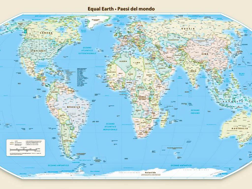
The African Union (AU) has officially endorsed a campaign to replace the Mercator map, widely used since the sixteenth century, with a geographically more accurate projection. According to the continental organisation, the aim is to correct a historical distortion that artificially reduces the size of Africa and to strengthen the continent’s position on the international stage.
Created in 1599 by the Flemish cartographer Gerardus Mercator for maritime navigation, this projection was one of the first to represent imaginary and curved sailing routes as visible straight lines. Its simplicity for maritime navigation helped consolidate its popularity at the time, but its enormous distortions soon became difficult to ignore. In fact, the Mercator projection enlarges regions close to the poles, such as North America and Greenland, while significantly reducing those along the equator, such as Africa and South America, in order to maintain a constant direction.
“It may seem like just a map, but in reality, it is not,” Selma Malika Haddadi, Vice-President of the AU Commission, told Reuters. “This projection created the illusion that Africa is marginal,” since the continent appears slightly smaller than the Arctic territory of Greenland. Africa is in fact the second-largest continent in the world, more than fourteen times the size of Greenland, and is home to more than a billion people and dozens of nations. Europe, too, which is depicted as larger than South America on the Mercator map, is actually only half its size.
The “Correct The Map” campaign, led by the organisations Africa No Filter and Speak Up Africa, is promoting the adoption of the Equal Earth projection, introduced in 2018 and designed to represent the continents according to their actual size. “The current size of Africa on the map is wrong,” said Moky Makura, Executive Director of Africa No Filter. “This is the world’s longest-running disinformation campaign, and it must end.”
Beyond being a simple cartographic issue, supporters of the reform believe that this distortion affects education, the media and public policy. Fara Ndiaye, co-founder of Speak Up Africa, stressed that the use of the Mercator map has an impact on African identity and pride.
The African Union, which has 55 member states, has confirmed that this struggle forms part of its ambition to “restore Africa’s rightful place” on the global stage, echoing growing calls for reparations for colonialism and slavery.
The campaign extends beyond the continent. The Caribbean Community (Caricom) Reparations Commission has also supported the Equal Earth projection, viewing it as a rejection of the “ideology of power and domination” conveyed by the Mercator map.
While some institutions, such as the World Bank, already use the Winkel Tripel or Equal Earth projections for their static maps, Mercator maps remain the standard in many contexts, including schools and digital applications. Google Maps, for example, abandoned the Mercator view only in 2018 on its desktop version, but continues to use it by default on mobile devices. The US space agency NASA’s Goddard Institute for Space Studies (GISS) has also adopted the Equal Earth projection in order to avoid gross distortions of size.
For centuries, experts have debated the question: is it possible to represent an accurate three-dimensional, spherical world on a flat surface? Can you take a rounded object, such as a football, cut it open, glue it onto a board and obtain an accurate representation of it? Many experts conclude that the answer is a clear no. Maps, they argue, are inherently a form of falsehood, always involving compromises over something: area, distance or something else. Others, however, argue that almost perfect maps do exist and that they should be highlighted.
Over time, various map projections have attempted to address the shortcomings of Mercator, but all have involved compromises in one or more factors. This has made it difficult for advocates of social justice to support a projection that would better represent the Global South.
See also: Troppo piccola per secoli, l’Unione Africana approva una mappa corretta dell’Africa
See also: YouTube video
 One day, a man sat down beside his son and said to him in a solemn voice: “My boy, in our lives there is only one true crime: murder. Always stay away from that path. Never lay a hand on [...]
  Once upon a time, in a village at the foot of a green mountain, there lived a boy called Elijah.
Elijah had a passion: butterflies. Not for studying them, nor for admiring them, but for keeping [...]
Once upon a time, in a village at the foot of a green mountain, there lived a boy called Elijah.
Elijah had a passion: butterflies. Not for studying them, nor for admiring them, but for keeping [...]  Between the Nile and the Red Sea lies the Atbaï Desert, one of the least explored regions of north-eastern Africa from an archaeological point of view. Long hidden beneath the sands, the remains [...]
  Once upon a time, in a small and peaceful village, there stood a carpenter’s workshop. Inside were many work tools: the saw, the plane, the hammer, the nails, the sandpaper, the file, the axe, [...]
  My friends, I am going to tell you a story that speaks to the heart, a story like clear water flowing gently through the soul, a lesson for a joyful life.
Once upon a time, there lived side by [...]
My friends, I am going to tell you a story that speaks to the heart, a story like clear water flowing gently through the soul, a lesson for a joyful life.
Once upon a time, there lived side by [...]  Let us listen carefully—both with intellect and discernment—to the story of the mwelele tree (a species of Ficus sycomorus) and the blind men in search of an elephant, for it is truly [...]
  If I were to ask God for a gift, a single gift, a heavenly gift, I would ask Him, I believe without hesitation, to grant me the supreme art of the smile. It is what I most envy in certain people. It [...]
 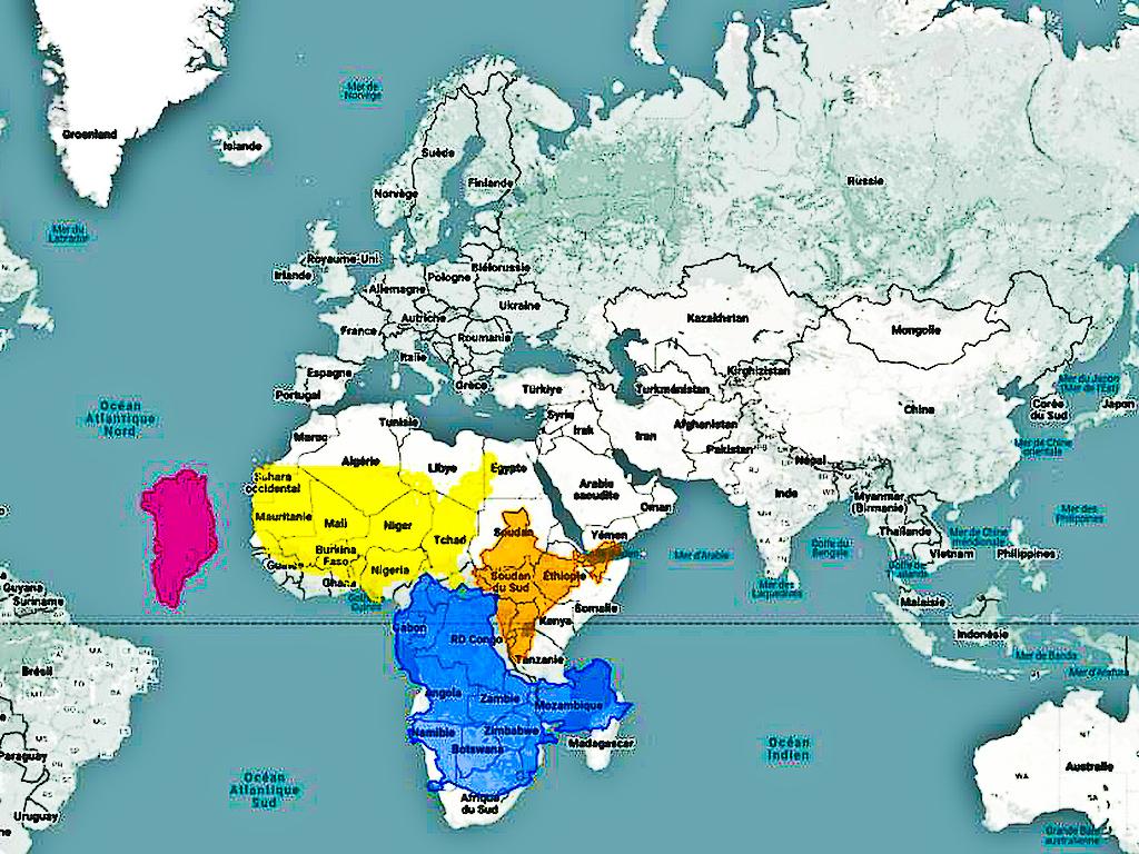 Greenland suffers from a serious case of the frog that wants to be as big as the ox. When you look at it on Google Maps, it parades with all the grandeur of a continent, appearing almost as large as [...]
  After many, many years spent alone, walking alone, singing alone and eating alone, Nasilele became bored with her loneliness and, one day, said to Nyambe: “I feel very sad and always feel like [...]
  Contemporary African art is experiencing a period of significant international visibility, with artists reshaping the global landscape and bringing new perspectives, histories and identities from the [...]
 Info
Email: jampypezzi@gmail.com - tel. +39 328 732 6990 / +243 991 457 856
This blog is made in 4 languages: it en fr es

 EDitt | Web Agency
Leave a comment